Air Dispersion Modelling predicts how pollutants are dispersed in the atmosphere from different pollution sources taking into account building influences, topography, meteorology, downwind distances, and other factors.
Air Dispersion modelling is a mathematical simulation of how air pollutants disperse in the ambient atmosphere. The simulation uses mathematical equations and algorithms to characterize the atmospheric processes that distribute an air pollutant emitted by a source over a wide area. These models are used to estimate or to predict ground level concentrations (GLC) at selected downwind receptor locations of air pollutants emitted from sources such as industrial plants, mines, vehicular traffic or accidental chemical releases.
I am using AERMOD Cloud since 2013, the application has evolved very well over the time.
I like this interface because it very simple to use and contains almost all modules and features
I require for perform air dispersion modeling for EIA studies in India.
Shailesh Jha Freelancer, New Delhi
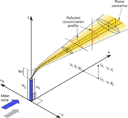
Gaussian Plume Air Dispersion Model
AERMOD Cloud ®
A truly integrated AERMOD air dispersion modelling system - AERMOD, AERMET, AERMAP and BPIPRM within ONE Interface.
Product Update: Discontinuation of Support for AERMOD Cloud Version 18
As of January 1, 2025, support for AERMOD Cloud Version 18 has been discontinued. This decision is part of our commitment to enhancing user experience and service quality.
We encourage all users to transition to AERMOD Cloud Version 24, which offers advanced features and improved performance. The upgrade is free of charge for perpetual license holders and current subscribers.
For assistance during this transition, please feel free to contact our software support team. We are here to help!
Overview
AERMOD Cloud® is an integrated graphical interface of U.S. EPA's AERMOD Modelling System. AERMOD is a
Gaussian Plume Air Dispersion Model. AERMOD Cloud consists of pre-processors modules like
AERMET,
AERMAP,
BPIPPRM and the model, which enable smooth flow of the data across the modules and model.
The application is developed specially in compliance with the Regulatory Requirements and considering
limitations of availability of the meteorological data.
AERMOD Cloud is predominantly used in Environmental Impact Assessment (EIA) Studies for the modelling of the
dispersion of air pollutants from various emission sources like Point, Area, Volume, Open Pit, Line, and
Polygon Area etc.
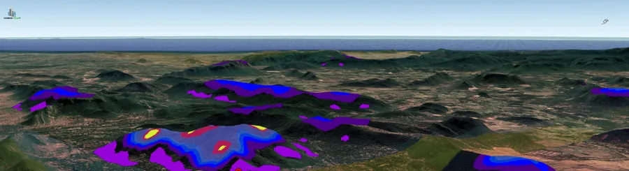
AERMOD Cloud allows you to export isopleth layer from the modelling project to a
KML
file, which can then be opened and project in 3D in Google Earth. This allows modeler to overlay isopleth
on the quality images provided by Google Earth.
AERMAP
For complex terrain situations, AERMOD captures the essential
physics of dispersion in complex terrain and therefore needs elevation data that convey the
features of the surrounding terrain. In response to this need, AERMAP searches for the terrain
height and location that has the greatest influence on dispersion for each individual receptor.
This height is the referred to as the hill height scale. Both the base elevation and hill height
scale data are produced by AERMAP as a file or files which can be directly inserted into an
AERMOD input control file.
A modeling domain is the geographic extent that includes all the receptors and sources
specified in a particular AERMAP run. The domain also defines the region of significant terrain
elevations within which the terrain data points are included in the calculation of hill height
scales.
Note that the terrain files
are required even if the user is providing the receptor heights because the terrain data are used
to obtain the hill height scale for each receptor. If the user specifies the receptor elevations,
they can be entered in either feet, meters, or decimeters. The output receptor elevations will
always be in meters.
Features
Experience the power of a truly integrated AERMOD air dispersion modelling system with AERMOD Cloud. Our innovative platform combines AERMOD, AERMET, AERMAP, and BPIPRM into a single, user-friendly interface, making it easier than ever to model the dispersion of air pollutants from various emission sources.
Designed primarily for Environmental Impact Assessment (EIA) studies, AERMOD Cloud provides advanced capabilities for modeling the dispersion of air pollutants from point, area, volume, open pit, line, and polygon area sources. With AERMOD Cloud, you can take your air quality assessments to the next level and make more informed decisions about the environmental impact of your projects.
Truly Integrated
A truly integrated AERMOD modelling system, consists of pre-processors, like AERMET, AERMAP and BPIPRM and model within ONE interface for smooth flow of data.
Built-in Terrain Data
The terrain data of 90 m resolution is built-in to run AERMAP and assess the impact of topography on air dispersion.
AERMET - Met Processor
The interface is integrated with AERMET, the meteorological data processor of AERMOD.
Includes feature to convert excel file into SAMSON file.
Multi Pollutant Modelling
Interface allow you to run multiple pollutants with single project file. No requirement of
creating individual files for each pollutants.
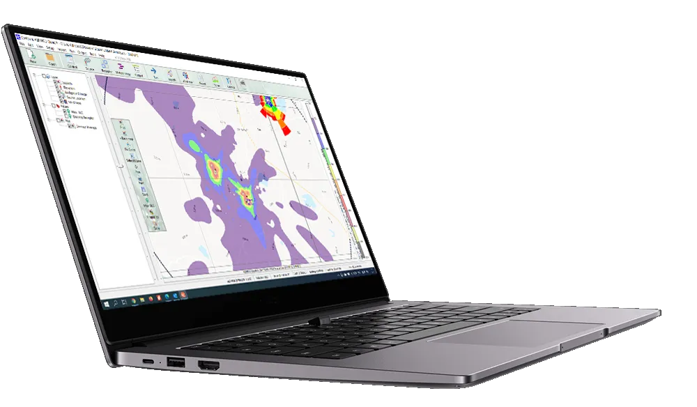
Output Visualization and Customize Overlay
Advanced post-processing with automatic gridding and contouring. Customize isopleth levels, colour, transparency, labels, fonts etc. Isopleth may be customized with various overlay option like, base-map, terrain contour, max GLC, GLC at discrete receptor, wind rose etc.
Multi Source Modelling
Interface can handle multiple emission sources simulations simultaneously; like. Point (Vertical, Horizontal, Capped), Area, Line, RLine, Polygon Area, Circular Area.
AERMOD Meteorological Data Viewer
A seamlessly integrated component of the AERMOD Cloud速 software suite, empowers users to effortlessly #visualize and analyze complex meteorological data essential for accurate air dispersion modelling. By presenting surface and profile data in a clear and intuitive format, this powerful tool enables users to quickly assess atmospheric conditions and generate insightful charts for key parameters.
This enhanced understanding of meteorological factors significantly improves the accuracy and effectiveness of air quality modelling efforts, leading to more informed decision-making and better outcomes.
Fast and Simple
Quick project setup by specifying a reference point (Latitude, Longitude) and modelling domain radius. Application automatically downloads geo-referenced base maps and configure AERMAP for elevation data.
Building Downwash
Integrated BPIPPRM model automate building downwash calculations without separate run.
AERMOD - Post Processor
With its powerful built-in post-processor, it offers a range of advanced visualization tools—such as contour plots, time-series analyses, multi-parameter result filtering, and percentile-based evaluations. These features empower professionals to interpret model outputs, understand meteorological patterns, and analyze dispersion behaviors with greater clarity.
Export Isopleth as KML
Isopleth can be exported to Google Earth file.
Techincal Specifications
AERMOD Cloud® is an interface for the US EPA air dispersion models - AERMOD, AERMET and AERMAP.
The followings are the technical specifications for these models:
Several types of grids (Cartesian, polar, linear) and discrete receptors
Other Options
Building downwash (modeled by BPIP-PRIME)
System Requirements
Windows 10, 11
Intel, 32-bit. 2 GHz or higher
Minimum 8 GB RAM
Display, 1366x768 with True Color
Mouse or other pointing device
Internet Connection
Subscribe AERMOD Cloud
Select Subscription Type
Important Notice: Before you purchase AERMOD Cloud, please be aware:
Expertise Required: This software serves as an interface for the US EPA AERMOD model, necessitating prior knowledge and expertise in environmental modeling. It is not a substitute for comprehensive training in AERMOD and Air Dispersion Modelling.
Support and Training Options:
Limited Support: Our team provides support for software-related queries, but we do not review input/output data or offer extensive training within this support framework.
Paid Training: For those seeking in-depth knowledge and practical skills in AERMOD, we offer specialized paid training programs. Learn more about our training programs.
By proceeding with the purchase, you acknowledge the above points and understand the nature of the support and learning resources available.
Loading...
AERMOD Cloud Updates
Software updates are offered free of charge to active subscriber and subscribe currently in maintenance.
To downlaod software updates, click the Login button, you will then be prompted to enter your User Name and Password
before entering the download site.
Please contact our support team if your login credential is misplaced.
We provide AERMET and AERMOD Model-ready Meteorological and Terrain datasets for any specific location.
The data is pre-processed appropriately to the standards of U.S. EPA.
Met Data - Same Day Delivery
Within 24-hour, we deliver model-ready files for any location inside INDIA for direct AERMOD or AERMET or CALPUFF model run.
We use necessary cookies to make our site work. We'd also like to set analytics cookies that help us make improvements by measuring how you use the site. These will be set only if you accept.
For more detailed information about the cookies we use, see our Privacy Page.


 AERMOD Cloud® is an integrated graphical interface of U.S. EPA's AERMOD Modelling System. AERMOD is a
Gaussian Plume Air Dispersion Model. AERMOD Cloud consists of pre-processors modules like
AERMOD Cloud® is an integrated graphical interface of U.S. EPA's AERMOD Modelling System. AERMOD is a
Gaussian Plume Air Dispersion Model. AERMOD Cloud consists of pre-processors modules like